3D LiDAR at CES 2021 Lowered an Autonomy Barrier
3D LiDAR at CES 2021 may not have generated the same consumer excitement as a new television, smartphone, or gaming system. However, GreatStar OLEI and MorpheusTEK introduced a sensor with the potential to influence how robots and autonomous machines understand the world around them.
The companies unveiled the OLEI LR-16F, a 16-channel 3D LiDAR sensor with a stated detection range of up to 100 meters. Its most attention-grabbing feature was the launch price: $1,750.
That price mattered because autonomous technology depends on much more than clever software. Robots, drones, mapping systems, and self-driving machines also need reliable ways to detect objects, measure distance, and move safely through changing environments.
When those sensors cost too much, promising ideas may never move beyond prototypes or limited pilot programs.
GreatStar OLEI and its North American partner MorpheusTEK presented the LR-16F as an industrial-quality sensor priced to make advanced perception technology accessible to more developers. Although affordability alone could not guarantee mass adoption, the announcement addressed one of the biggest barriers facing robotics companies.
What Is LiDAR?
LiDAR stands for Light Detection and Ranging.
The technology sends laser pulses into the surrounding environment and measures how long the light takes to return after hitting an object. Those measurements allow a system to calculate distance and create a detailed representation of nearby surfaces.
When a LiDAR sensor repeats that process rapidly across several directions, it can produce a three-dimensional collection of measurements known as a point cloud.
A machine can then use that information to identify walls, vehicles, people, equipment, trees, curbs, pallets, and other obstacles.
Cameras capture color, texture, signs, and other visual information. LiDAR serves a different purpose by providing direct measurements of distance and spatial structure.
For many autonomous systems, developers combine LiDAR with cameras, radar, GPS, inertial sensors, and artificial intelligence. Each technology contributes a different kind of information, creating a more complete understanding of the environment.
That reliance on several technologies helps explain why autonomous machines can become expensive so quickly.
The OLEI LR-16F Offered a 360-Degree View
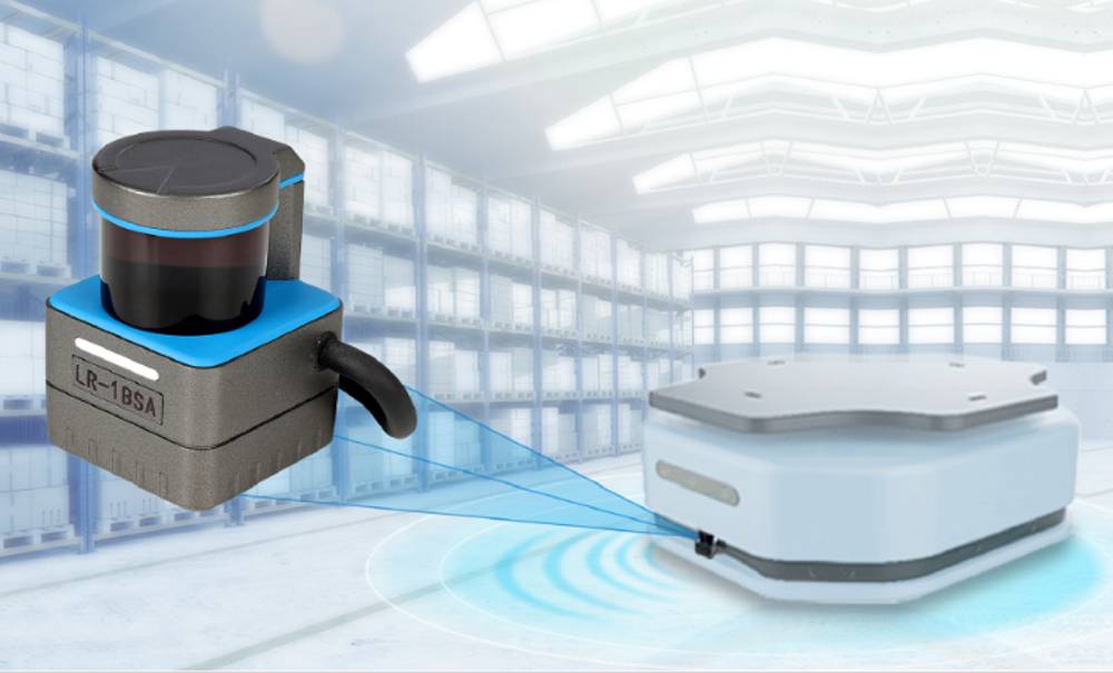
The LR-16F introduced at CES 2021 featured 16 scanning channels and a horizontal field of view covering 360 degrees.
In practical terms, the spinning sensor could scan the full area surrounding a machine rather than looking in only one direction.
GreatStar OLEI described the device as suitable for mapping, navigation, and obstacle detection. The company also listed a maximum sensing range of 100 meters.
Those capabilities could support machines moving through warehouses, roads, construction sites, public spaces, and outdoor environments.
MorpheusTEK’s original CES 2021 announcement for the $1,750 LiDAR positioned the sensor as a lower-cost option for companies developing autonomous and robotic systems.
The product remains part of MorpheusTEK’s LiDAR portfolio. However, the $1,750 figure represented its CES 2021 launch price and should not be treated as a current retail quote.
Lower Sensor Costs Could Open the Door to More Innovation
Building an autonomous machine requires developers to balance performance, safety, durability, and cost.
A highly accurate sensor may work beautifully in a laboratory. Nevertheless, the product will struggle commercially when its price makes the final robot unaffordable.
Sensor costs can become especially difficult for startups. A new company may need several units for testing, hardware development, field trials, demonstrations, and early production.
Reducing the cost of one critical component gives engineers more room to experiment. It may also help a company move from a small prototype toward a product that customers can realistically purchase.
Phil Hennessy, CEO of MorpheusTEK at the time of the announcement, compared that shift to the role the Ford Model T played in expanding access to automobiles.
This is equivalent to Ford bringing the Model T to the masses. When automobiles reduced cost, it triggered mass adoption.
Phil Hennessy, MorpheusTEK
The comparison was ambitious. A lower-priced sensor could not create an autonomous-technology revolution by itself.
Developers would still need dependable software, processors, power systems, connectivity, safety testing, maintenance, and a clear commercial use. Even so, less expensive perception hardware could remove one obstacle from that complicated process.
LiDAR Could Help Robots Navigate Warehouses
Warehouse and logistics operations represented one of the most practical markets for the LR-16F.
Autonomous mobile robots and automated guided vehicles can move inventory, transport materials, and support workers inside large facilities. To operate effectively, those machines must detect shelving, pallets, equipment, walls, and people.
A 360-degree LiDAR sensor can help a robot understand its position while identifying obstacles around it.
Unlike a demonstration area created for a trade show, a working warehouse constantly changes. Employees move through aisles, pallets appear in new locations, and equipment may block a previously open route.
Autonomous systems must recognize those changes and respond without creating additional danger.
Lower-cost LiDAR could make these systems more attainable for manufacturers, distributors, and logistics companies. However, employers should not frame warehouse automation only as a way to remove workers.
Responsible deployment should also reduce injuries, support employees during physically demanding tasks, and create opportunities for workers to develop technical skills.
Drones Need More Than a Camera
Drones represented another possible application for affordable 3D LiDAR.
A camera can capture powerful images from the air, but it does not always provide enough information for precise distance measurement or three-dimensional mapping.
LiDAR can help drones measure terrain, inspect infrastructure, map forests, examine construction sites, and identify physical obstacles.
The technology may also support agricultural mapping and crop management. When combined with other sensors, aerial measurements can help farmers and researchers understand variation across land.
That work connects with the broader transformation I examine in The Future of Farming: How Precision Agriculture Is Reshaping the Industry. Better spatial information can support more informed decisions, although data only becomes valuable when people can interpret and act on it.
Weight, power consumption, weather, and flight time remain important constraints for drone-mounted LiDAR. Therefore, no single sensor will suit every aerial application.
Autonomous Vehicles Must Understand a Complicated World
Self-driving vehicles often dominate public conversations about LiDAR.
An autonomous vehicle must identify lanes, pedestrians, cyclists, other vehicles, construction zones, and unexpected objects. It also needs to estimate distance and respond within fractions of a second.
LiDAR can contribute detailed spatial measurements, but it cannot solve the entire challenge alone.
Heavy rain, fog, dust, reflective surfaces, interference, and complex traffic patterns may affect how sensing systems perform. Engineers therefore use sensor fusion to combine information from several sources.
Artificial intelligence helps interpret that information and decide what the machine should do next. Yet an algorithm can make dangerous mistakes when its training data fails to represent real-world conditions.
I explore those broader questions in The Rise of AI: Promise, Risks, and the Future We Are Building. Autonomous technology requires more than impressive demonstrations. It needs transparency, accountability, strong testing, and meaningful human oversight.
My coverage of John Deere’s autonomous tractor at CES 2022 examines a related use of cameras, GPS, artificial intelligence, and remote supervision in agriculture.
Affordable LiDAR Could Support Safer Cities
GreatStar OLEI also identified traffic monitoring, mobile mapping, and smart-city systems as possible applications.
LiDAR can measure the movement of vehicles and people without relying exclusively on conventional video. Cities may use spatial data to study intersections, improve traffic flow, map infrastructure, or identify dangerous transportation patterns.
Those applications could support safer streets. Still, the phrase “smart city” should never prevent the public from asking who collects the information and how authorities use it.
Even when a sensor does not capture a recognizable face, patterns of movement can reveal sensitive details about individuals and communities.
Public agencies should establish clear limits on retention, access, sharing, and surveillance before deploying widespread sensing systems.
A safer city should not require residents to surrender all expectations of privacy.
Accessibility Could Benefit From Better Spatial Awareness
Affordable sensing technology may also create opportunities beyond vehicles and industrial robots.
Developers could use LiDAR to support navigation tools for blind and low-vision users, map inaccessible spaces, or help mobility devices detect obstacles.
However, designers must build those products with disabled people rather than merely building for them.
A technically accurate sensor does not automatically create an accessible experience. Developers must also consider comfort, affordability, reliability, sound, vibration, battery life, and how the technology works in crowded environments.
Meaningful innovation begins with the needs and priorities of the people expected to use it.
The Global Supply Chain Helped Lower the Price
GreatStar OLEI and MorpheusTEK attributed the sensor’s launch price partly to their international manufacturing and supply network.
The companies described a collaborative structure involving design work in the United States, laser components from Germany, sensor technology from Japan, and manufacturing in China.
GreatStar OLEI also benefited from purchasing and manufacturing at a larger scale than many robotics startups could achieve independently.
Those economies of scale can lower component prices. Nevertheless, global supply chains also create vulnerabilities.
Shipping delays, trade disputes, material shortages, factory disruptions, and geopolitical tensions can affect production. Companies must therefore consider resilience alongside cost.
Ethical sourcing matters as well. Low prices should not depend on unsafe working conditions, environmental damage, or labor exploitation hidden deep inside the supply chain.
Lower Prices Do Not Remove Every Barrier
The $1,750 launch price represented an important part of the CES announcement. Still, hardware cost was only one barrier to autonomous-technology adoption.
A company also needs engineers who can integrate the sensor, interpret point-cloud data, calibrate equipment, create maps, and build reliable navigation software.
Testing adds another layer of expense. A robot that performs well inside a controlled facility may struggle when exposed to rain, dust, vibration, extreme temperatures, or unpredictable human behavior.
Maintenance, cybersecurity, insurance, regulations, and product liability also influence whether a system becomes commercially viable.
Consequently, describing one affordable sensor as the final barrier broken would overstate the case.
A more accurate conclusion is that GreatStar OLEI reduced one significant obstacle. The company offered developers another option for building autonomous systems without placing the highest-cost sensor at the center of every design.
Autonomous Technology Must Earn Public Trust
Better sensing may help machines avoid obstacles and navigate more accurately. However, the public will judge autonomous technology by more than technical performance.
People will want to know who remains responsible when a robot causes harm. Workers will ask whether automation will improve their jobs or eliminate them. Communities will question how companies and governments use the data collected around them.
Developers must answer those concerns before widespread deployment rather than after a serious failure.
Trust requires clear safety standards, independent testing, human override systems, cybersecurity protections, and honest communication about limitations.
Affordability can accelerate innovation, but speed should never outrun responsibility.
What the $1,750 LiDAR Meant at CES 2021
GreatStar OLEI’s 3D LiDAR stood out at CES 2021 because it focused on the hidden infrastructure behind autonomous technology.
Consumers often see the finished robot, drone, or self-driving vehicle. They rarely see the complex collection of sensors that allows the machine to understand where it is.
By introducing a 16-channel, 100-meter LiDAR at a launch price of $1,750, GreatStar OLEI and MorpheusTEK argued that advanced perception could become accessible to more developers.
That accessibility could support innovation in warehouses, agriculture, mapping, transportation, construction, and mobility.
Nevertheless, the future of autonomy will not depend on price alone.
Successful systems must also prove safe, reliable, repairable, secure, and useful in the environments where people expect them to work.
The most meaningful breakthrough will not arrive when machines simply become more autonomous.
It will arrive when that autonomy creates genuine value while protecting workers, communities, privacy, and human life.
Explore more stories about emerging technology, startups, and the ideas shaping our future through my CES coverage on DG Speaks.